Background
TerraLitix Audit

The first comprehensive platform for contaminated soils

All contaminated-soil operations in one platform

TerraLitix integrates field capture, data management, and technical visualization into a digital workflow, optimizing every phase of your contaminated-soil projects.

PHASE I

Create the digital site record

Select parcels from cadastral records and build your site. Overlay the client's plan, aerial orthophotos, or your own layers in PNG and GeoTIFF, visually aligned.

PHASE II

Record your study campaigns

Log borings, test pits, vapor probes, piezometers, and groundwater monitoring. Everything georeferenced and structured for analysis and reports.

Data capture
in the field

TerraLitix structures field data capture so that observations, samples, and technical records stay organized, traceable, and connected to the site record.

Structured logging

Observations, incidents, and technical data from the moment of capture.

Sampling and traceability

Samples, location, and documentation within the same flow.

Real field operations

Works on a ruggedized tablet, even without a connection.

Geolocated data

Sampling points are tied to coordinates and metadata, ensuring traceability at every step.

Cross-sections, plumes, and isolines on the site plan

Cross-sections on a four-layer model, auto-generated lithological columns, and contamination plumes with kriging — all on the site plan.

Lithological columns view in TerraLitix

Lithological columns

Automatically organize and render subsurface layers from boring data.

TerraLitix vs a scattered stack

Compare the 10 key modules of the technical workflow — capture, conceptual model, lab, plotting, lithology, GIS, reports, and handover — against the scattered stack a consultancy uses today.

MODULES

Coming soon

Road map

TerraLitix builds on the data you already capture to take you to the next level: from the site record to the predictive model, from the cross-section to the digital twin.

09Coming soon

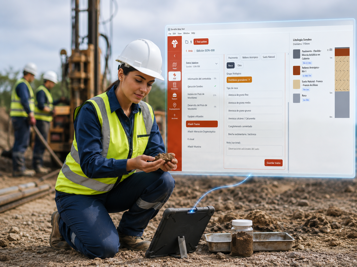
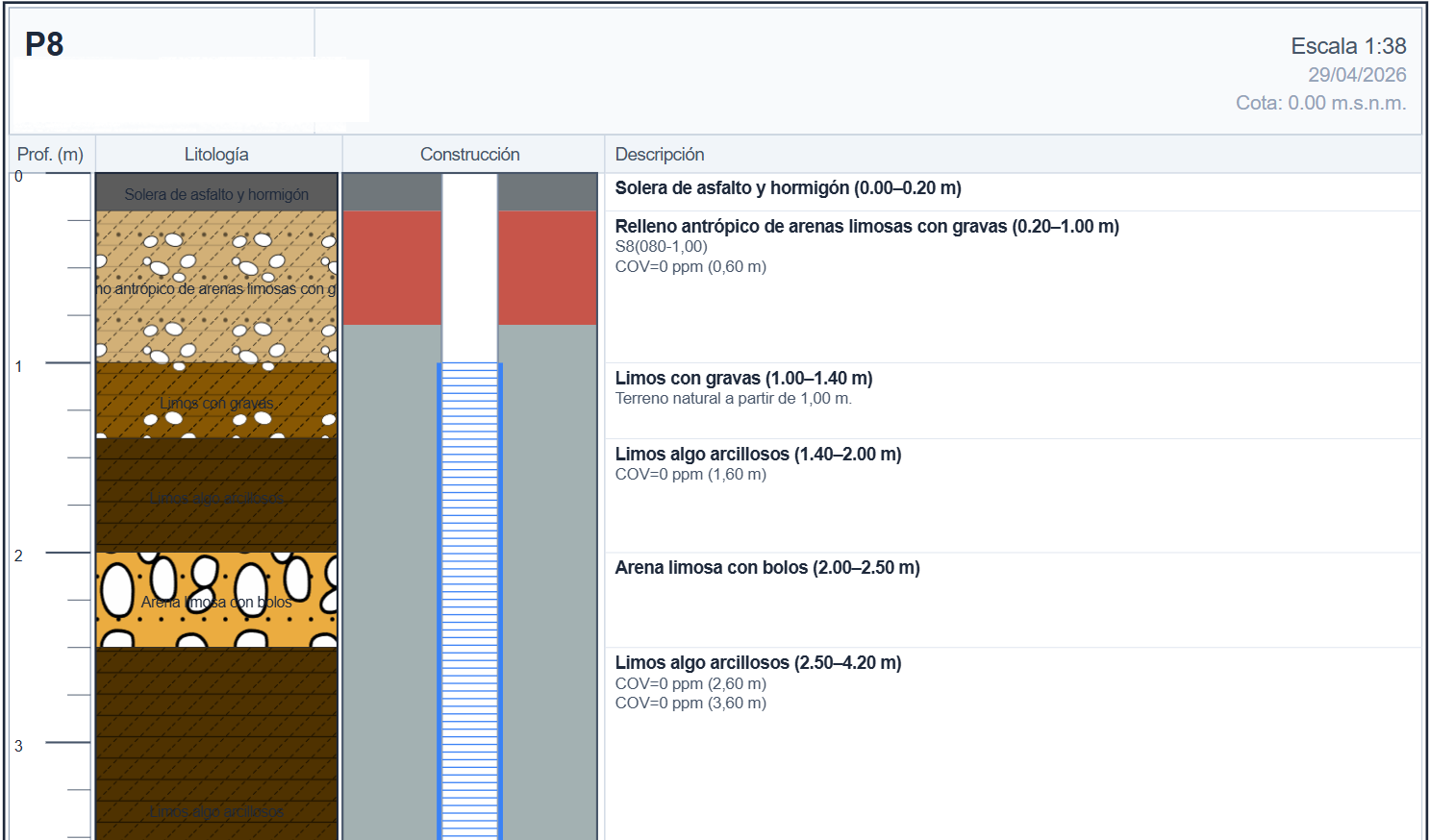
Integrated quantitative risk analysis (RBCA)

Quantitative Risk Analysis in collaboration with the firm that authored the original RBCA Toolkit, the global reference in soil risk assessment. Visual composition of the conceptual model inside the platform, direct execution of Tier I and II scenarios, and calculation of intervention levels in line with applicable soil-contamination regulations.

10Coming soon

3D digital twin of the subsurface

Three-dimensional reconstruction of lithology and stratigraphy from the borings and JAMES cross-sections you already generate. Immersive visualization of the contamination plume and its temporal evolution — from the 2D cross-section to a navigable model.

11Coming soon

Hydrogeological modeling (MODFLOW)

Flow and transport simulation on top of the piezometry data you already collect. Predict contaminant migration, assess travel times, and design hydraulic barriers without leaving TerraLitix.

12Coming soon

LIDAR-based digital twins

LIDAR capture of the site integrated as a high-resolution cartographic layer. A faithful 3D model of installations, topography, and vegetation that complements the subsurface twin and completes the full site representation.

Talk to our team

Discover TerraLitix and how it can transform the way you work.