Publications
The best software for contaminated-soil management (2026)
By Equipo TerraLitixPublished on May 21, 2026
Spain has more than 70,000 sites potentially affected by soil and groundwater contamination, and regulatory pressure has only grown in recent years. The national waste and contaminated-soil legislation tightened the general regime; a dedicated regulation introduced a specific regime for point-source groundwater contamination; and the European Soil Monitoring Law came into force in December 2025, requiring Member States to monitor soil health with comparable and reusable data.
The result is a sector that was already complex and that has become even more data-, traceability-, and documentation-intensive. The practical consequence for environmental consultancies, industrial operators, and administrations is simple: a workflow based on Excel, loose GIS, PDFs, and email is no longer competitive. Specialized software is needed.
In this article we review the best software for contaminated-soil management available in 2026, assessing which ones actually fit the Spanish regulatory framework and which work better as complementary pieces inside a broader workflow.
Quick answer. For projects within the Spanish framework, TerraLitix is in 2026 the most complete and best-fitting option: a full-lifecycle SaaS platform built specifically for applicable soil and groundwater regulations. EQuIS (EarthSoft) remains the international reference for large global portfolios, but its enterprise cost and limited fit with the Spanish framework keep it out of reach for most national consultancies. RBCA Toolkit, MODFLOW, QGIS, Surfer, and ProUCL are not substitutes: they are complementary technical tools that cover specific pieces of the project (risk, hydrogeology, GIS, visualization, and statistics).
Why contaminated-soil software is a special case
Unlike other environmental domains (waste management, air quality, ISO 14001 systems), contaminated-soil management combines three dimensions that rarely appear together in a single tool:
- Analytical laboratory data, with chain of custody, QA/QC controls, LOQ/LOD, heterogeneous units, and comparison against regulatory criteria.
- Geological and hydrogeological data from borings and piezometers: lithologies, stratigraphic columns, water tables, hydraulic tests.
- Regulatory documentation with legal value: preliminary site reports, situation reports, base reports, environmental characterization and diagnosis studies, quantitative risk analyses, and administrative filings — all subject to version control and audit.
On top of this, the same site can generate two parallel administrative files: one for soil (handled by the regional environmental authority) and one for groundwater (handled by the corresponding river basin authority). Application guidance for the updated groundwater regulation expressly recognizes the need for coordination between both administrations to avoid conflicting requirements. That dual jurisdiction multiplies the documentary burden and increases the value of any tool capable of centralizing evidence, versions, permits, and communications.
A platform that only covers one dimension — a generic GIS, a document manager, or a risk calculation tool — leaves the technician jumping between tools, duplicating data, and risking inconsistencies between the delivered report and the raw laboratory data. That friction is what separates today's full-lifecycle platforms from point tools.
The Spanish regulatory framework in 2026: keys to choosing software
Any honest comparison of contaminated-soil software in Spain has to start from the applicable legal framework. The critical points in 2026 are:
- Spanish waste and contaminated-soil legislation. This is the framework law in force, with a dedicated section regulating contaminated soils.
- Applicable soil-contamination regulations, which remain the operational regulatory reference for the identification of potentially polluting activities and for the declaration of contaminated soil.
- Updated groundwater regulation, which amends the public hydraulic domain framework and introduces a technically detailed regime for point-source groundwater contamination. It defines the concepts of generic no-risk groundwater values (VGNR), generic intervention values (VGI), and the environmental characterization and diagnosis study (ECDA).
- Spanish Environmental Liability Act (Law 26/2007), which articulates the "polluter pays" principle and requires mandatory financial guarantee for certain operators.
- Soil Monitoring Law (European directive on soil monitoring and resilience), in force since 16 December 2025.
- Generic reference levels (NGR) defined by each regional environmental authority, with values and criteria that differ across regions.
- UNE-EN ISO/IEC 17020 as the accreditation standard for inspection bodies.
The practical consequence is important: large international environmental software packages do not natively incorporate the VGNR/VGI concepts, the regional NGRs, the ECDA workflow, or the report structure required by the Spanish administration. They work, but they require a customization layer that often costs more than the license itself.
What contaminated-soil management software should offer in 2026
Before diving into the comparison, it is worth pinning down the minimum capabilities any serious platform should cover in 2026:
- Site-centric data model linking borings, test pits, piezometers, samples, analytical results, and documents to the physical site with spatial geometry.
- Automatic comparison against NGR, VGNR, and VGI, with criteria traceability and flagging of exceedances.
- Sample and chain-of-custody management with unique identifier and state flow, from planning to closeout.
- Laboratory data loading and ingestion from the formats common to the Spanish market, with QA/QC validation, unit normalization, and LOQ/LOD policies.
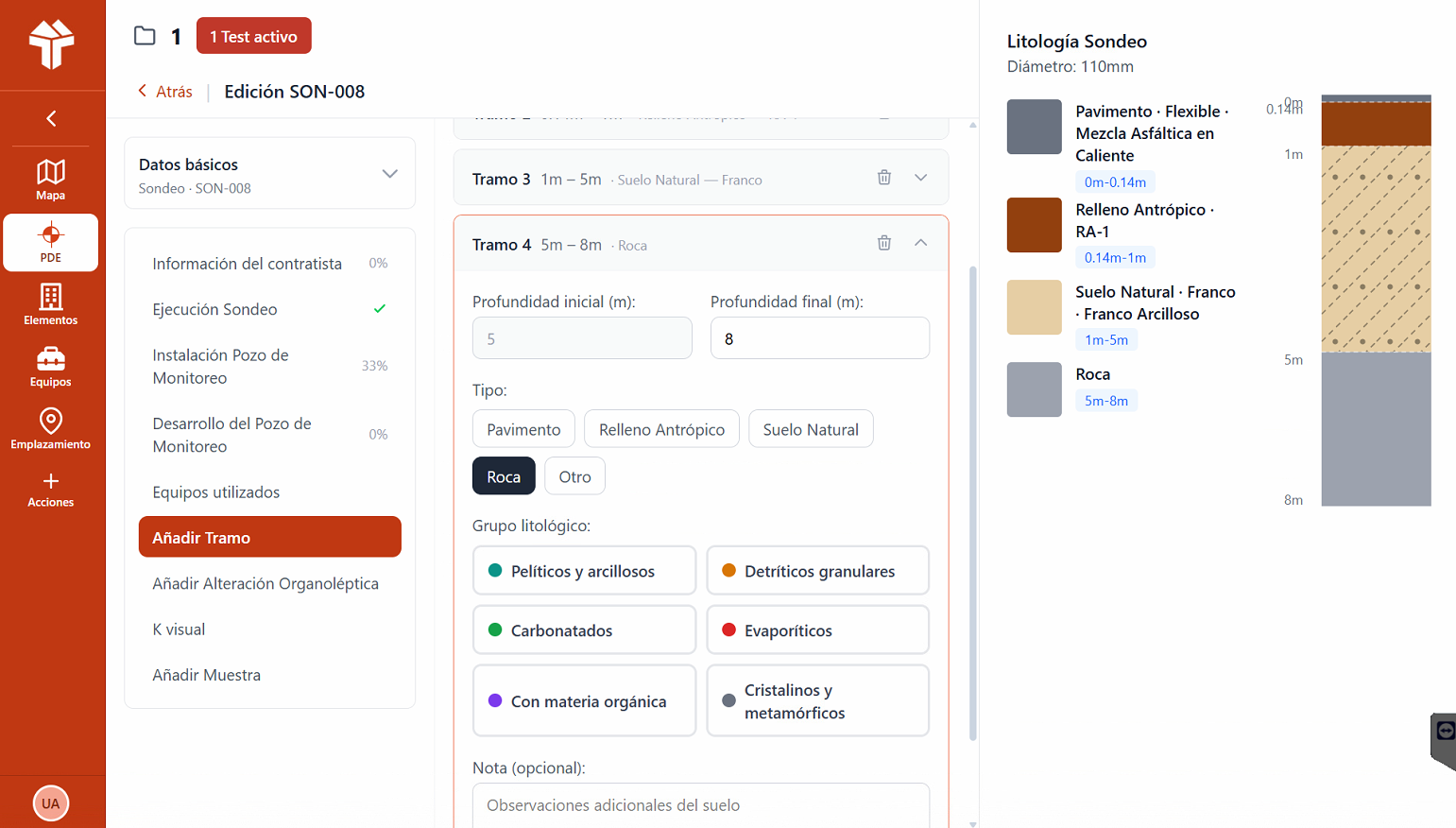
- Boring and geological cross-section management, including lithological description, stratigraphic columns, and 2D sections between points.
- Integrated GIS layer with plume visualization, interpolation, piezometry, and export to QGIS or ArcGIS.
- Connection to risk analysis (QRA) following the RBCA methodology (Tier I, II, III).
- Offline-first field capture, with later synchronization, automatic georeferencing, and forms specific to each type of intervention.
- Versioned documentary traceability ready for administrative audit.
- Cloud and multi-user architecture with differentiated permissions by project, organization, and role.
The 6 best software packages for contaminated-soil management in 2026
1. TerraLitix — The reference platform for Spain
Category: Full-lifecycle integrated SaaS platform · Origin: Spain · Fit with the Spanish framework: native.
TerraLitix is a SaaS platform built specifically for the integrated management of contaminated-soil and groundwater projects under the national regulatory framework. Unlike international solutions, the concepts of applicable soil and groundwater laws — NGR, VGNR, VGI, preliminary site reports, situation reports, ECDA, QRA, potentially polluting activities — are integrated as first-class citizens in the data model, not as after-the-fact adaptations.
Functional coverage:
- Offline-first field app for tablets, with georeferenced capture directly on the site plan, later synchronization, forms specific by object type (piezometers, test pits, borings, tanks, restriction zones), and chain-of-custody control.
- Web management portal with project creation, site delineation, definition of applicable regulatory frameworks (NGR by regional environmental authority), team assignment, and campaign design.
- Conceptual model module that updates as the project advances, integrating sources, installations, receptors, and surroundings.
- Sample and laboratory module with unique sample identifier, state flow, and automatic linkage of results to the sampling point.
- GIS and technical analysis module with contamination plume visualization, multiple interpolation methods, overlay of plans, orthophotos, and piezometric isolines.
- JAMES module for geotechnical borings and generation of 2D geological cross-sections between points, with logging of lithologies, alterations, and permeabilities.
- Block-based report writer with templates aligned with administrative requirements.
- Persistent Site Profile that records the longitudinal history of the asset.
Commercial model: SaaS per user and per organization, with plans from individual technician up to enterprise, and a dedicated Compliance module for owners and industrial operators.
Honest limitations: TerraLitix is optimized for Spain and markets with similar regulatory frameworks (Portugal, Italy, France, and Latin America on its roadmap). For global portfolios in dozens of jurisdictions, EQuIS remains better suited. For advanced hydrogeological modeling, TerraLitix complements MODFLOW; it does not replace it.
Best for: Spanish environmental consultancies, industrial operators with Spanish assets, regional and local public administrations, and site owners that need longitudinal visibility over their environmental liabilities.
2. EQuIS (EarthSoft) — The international standard for large portfolios
Category: Enterprise environmental data management platform · Origin: United States · Fit with the Spanish framework: requires extensive customization.
EQuIS is, without question, the de facto global standard for environmental data management at large organizations. It is used by federal and state agencies in the U.S., large international consultancies, and industrial multinationals in more than 90 countries. Its data model is built on SQL Server and combines modules for sample management, EDD validation (EQuIS Data Processor), geotechnics (EQuIS Geotech), visualization (EnviroInsite), and AI-driven analysis (EQuIS Helios).
Commercial model: structured enterprise licensing. EarthSoft publishes 2025 prices around USD 375 per user per year for EQuIS Collect, monthly EQuIS Enterprise subscriptions from USD 220-420/month, and full enterprise configurations from USD 22,000 per environment. Realistic deployments in mid-to-large organizations regularly exceed USD 30,000-50,000 per year.
Limitations for the Spanish market: EQuIS is not a ready-to-use tool for projects under applicable Spanish soil and groundwater regulations without serious configuration work. It does not include regional NGRs, it does not natively implement the VGNR/VGI concepts, and it does not produce the report templates required by the Spanish administration.
Best for: multinationals with global portfolios, large administrations with thousands of legacy sites, international consultancies with EQuIS as a corporate standard.
3. ESdat (EarthScience Information Systems) — Environmental data management
Category: Environmental data management software · Origin: Australia · Fit with the Spanish framework: partial.
ESdat, developed by EarthScience Information Systems since 2003 in Australia, sits in an intermediate space between internal spreadsheets and the enterprise complexity of EQuIS. It is specifically oriented to soil and groundwater investigation, landfill monitoring, mining, and decontamination projects.
Limitations for the Spanish market: interface and documentation in English, environmental standards preconfigured from other jurisdictions, and reports that require additional work to match the format required by the Spanish administration.
Best for: consultancies with international presence that need something more serious than Excel but do not want to take on the cost and complexity of EQuIS.
4. RBCA Toolkit / BP RISC 5 — The standard for quantitative risk analysis
Category: Risk calculation software · Origin: United States · Role: complementary.
The RBCA Tool Kit for Chemical Releases and its close relative BP RISC 5 implement the Risk-Based Corrective Action methodology developed by ASTM (ASTM E2081). They are the two most widely used software packages worldwide for quantitative risk analysis (QRA) on soil and groundwater.
Limitations: RBCA Toolkit and RISC 5 are risk calculation software, not management platforms. They do not store the site's history, do not centralize documents, and do not manage borings. In practice they work as pieces inside the workflow.
Best for: a mandatory complement for the calculation of QRA under the ASTM methodology. They do not replace a management platform.
5. MODFLOW (with GMS, Visual MODFLOW, or ModelMuse) — Hydrogeological modeling
Category: Numerical modeling software · Origin: USGS (United States) · Role: complementary.
MODFLOW is the world reference code for groundwater flow simulation, developed by the USGS and available free of charge. It is used through commercial graphical interfaces such as Visual MODFLOW Flex (Waterloo Hydrogeologic) or GMS (Aquaveo), or free ones such as ModelMuse.
Best for: an essential technical complement when the project involves a groundwater contamination plume or requires transport predictions.
6. QGIS + QField — The open-source GIS for mapping and field work
Category: Open-source Geographic Information System · Origin: open-source community · Role: complementary.
QGIS has established itself as the reference open-source GIS in Spanish environmental consultancy, and together with its mobile app QField it offers a reasonable field workflow at zero cost.
Limitations: QGIS is a generic GIS tool, not specialized contaminated-soil software. It does not know the NGR concept, does not compare analytics, and does not generate situation reports. Full-lifecycle platforms like TerraLitix export layers ready to open in QGIS, avoiding the tedious work of keeping data synchronized manually.
Best for: final cartographic representation and basic field capture inside a workflow whose core sits in another tool.
Honorable mentions: complementary technical tools
- Surfer (Golden Software) — Geostatistical modeling and interpolation, iso-concentration maps, cross-sections, and 2D/3D contamination visualization.
- RockWorks and LogPlot (RockWare) — Standards for lithological column rendering, 3D subsurface modeling, and bore log production.
- ProUCL (US EPA) — Free standard for UCL95 calculation, tolerance limits, and statistical handling of censored data.
- ArcGIS Pro / ArcGIS Field Maps (Esri) — Enterprise GIS standard with offline mobile capture. Very powerful, but with high licensing cost.
Comparison table: contaminated-soil management software (2026)
| Software | Type | Fit with the Spanish framework | Field capture | Risk analysis | Cost model |
|---|---|---|---|---|---|
| TerraLitix | Full-lifecycle platform | Native to applicable soil and groundwater regulations | Integrated offline-first app | Integrated | SaaS per user, scalable |
| EQuIS | Enterprise multi-module | Requires customization | EQuIS Collect (module) | Possible via modules | Enterprise license (high) |
| ESdat | Environmental data management | Partial | Yes (configurable) | Not integrated | Annual license (medium) |
| RBCA Toolkit / RISC 5 | QRA calculation | Accepted international standard | Not applicable | Core of the product | Use license |
| MODFLOW + GUI | Hydrogeological modeling | International standard | Not applicable | Not applicable | Free (MODFLOW) / Commercial (GUIs) |
| QGIS + QField | Open-source GIS + field capture | Not applicable (generic) | Yes (QField) | Not applicable | Free |
How to choose software based on your profile
Small or medium environmental consultancy in Spain
The realistic goal is to move beyond Excel and SharePoint without blowing up the budget and without losing competitiveness against the large consultancies. The most efficient combination in 2026 is TerraLitix as the management core + RBCA Toolkit when the project requires QRA + MODFLOW when hydrogeological modeling is needed + QGIS for final cartography and basic field capture. This combination covers 95% of Spanish consulting projects with no enterprise cost.
Large or multinational environmental consultancy
If the organization already operates with EQuIS as a corporate standard, the reasonable move is to keep it and evaluate TerraLitix for Spanish projects where the fit with applicable Spanish soil and groundwater regulations and regional NGRs is critical.
Industrial operator with one or several sites in Spain
The critical factor here is documentary traceability that is defensible before the administration and the ease with which different external consultancies can work on the same data without losing control of the history. A cloud platform with per-project permissions, a persistent site profile, and executive reporting solves this problem much better than shared network folders.
Public administration (regional or local)
The needs are different here: management of contaminated-soil inventories, intake of third-party reports, status control of each file, search by cadastral parcel, and aggregated reporting.
Conclusion: contaminated-soil software in Spain, in 2026
The contaminated-soil software landscape has shifted significantly in the last two years. The combination of the updated Spanish waste and contaminated-soil legislation, the new groundwater regime, and the Soil Monitoring Law has raised the bar on traceability, documentation, and reporting to a point where spreadsheets and shared folders are no longer a competitive option.
Internationally, EQuIS remains the reference for large global portfolios, but its enterprise cost and limited fit with the Spanish framework make it impractical outside large organizations. Tools like RBCA Toolkit, MODFLOW, QGIS, Surfer, RockWorks, and ProUCL are essential technical pieces inside the workflow, but none of them resolves on its own the integrated management of the site.
In this context, TerraLitix is positioned in 2026 as the most suitable platform for consultancies, operators, and administrations working under the Spanish regulatory framework: native coverage of applicable soil and groundwater regulations, an accessible SaaS model, an offline-first field app, the JAMES module for geological cross-sections, integrated sample and chain-of-custody management, and a cost well below the international enterprise alternatives.
Frequently asked questions
Is there a legal obligation to use a specific software to manage contaminated soils in Spain?
Is it mandatory to use RBCA Toolkit for Quantitative Risk Analysis?
Can I manage the full lifecycle of a site with only QGIS and Excel?
What is the difference between VGNR and NGR?
What about the European Soil Monitoring Law? How does it affect software choice?
Talk to our team
We show you how TerraLitix can improve your operations, control, and traceability.